Friday, November 19, 2010
Well our trip is over. It seemed like we were gone a month instead of just two weeks. The flight home was good. We sat in the front row and were getting personal service from the stewardess up front. She hit it off with Chris and they had a great conversation all the way home which helped pass the time. We flew SouthWest and it was a great experience both ways. We arrived in Buffalo around 6:30 pm which gave Chris enough time to hit the Christmas Tree store and we stopped at Bob Evans for dinner before heading home.
Nice to be home, but I'd be back in Arizona in a flash if I could.
Thanks for joining us for our wonderful adventure.
Last Day
Thursday, November 18, 2010
Phoenix and Scottsdale are surrounded by mountains that seem to just spring right out of the ground. Some are even within the city limits. Today we went to South Mountain Park, which is within the Phoenix city limits. This is the service building at the entrance to the park.

Of course the park is shared with cowboys and their horses.

Its over a 6 mile drive to the top of the mountain.

There are many vistas along the way up.


Once to the top the view is pretty spectacular! You can see for miles.

Not sure what this dwelling is near the top?

The city of Phoenix below.

Looking right towards Scottsdale.

Downtown Phoenix. The views were a little hazy, probably due to the 80 degree temps. 8O)


The seguaros are everywhere to be seen. They sure are survivors.


We returned from the Park to visit the balance of Old Town Scottsdale, an area we have grown very fond of. And of course we had to pay another visit to the Sugar Bowl! Just as good second time around!

This gentleman sat at a table near us. Notice anything strange?

A closer look shows that he's packing! That's a hand gun stuffed in a holster in the ass of his pants! Wouldn't want to piss him off!! Evidently, its not that uncommon in these parts, but it sure threw me for a loop.

More horses. Couldn't count the number of monuments of horses.

We found Phoenix to be not very impressive although we only drove through it. Much more poverty than Scottsdale and even some of the other suburbs (Tempe, Sun City, Mesa). Actually, never saw ANY poverty in Scottsdale. Most people that work there live outside Scottsdale where housing is more affordable.
All in all a great way to spend our last day in Arizona.
Old Town Scottsdale
Wednesday, November 17, 2010
Today we discovered Old Town Scottsdale. This area is the original townsite of Scottsdale.

We parked right near this sweatheart! A 1970's vintage Cobra kit car.

Can we yours for $30K.

It's a nice change from the ultra modern high end malls in the area. As it turns out, it is only a few blocks from the Fashion Square Mall that we visited earlier in the week.

They love their horses around here.

Life is surely good!!

Their motto for Old Town Scottsdale is "Where the Old West meets the New West"
Here's a good example. Unfortunately, no "Ride-Through", so she had to tie him up to the rail while she went in to do her banking!


We made the compulsary stop at the Sugar Bowl restaurant, a local landmark.


Now that looks good!!!

mmmmmmmmmm........

We've certainly seen our share of Classic Cars this week. They're everywhere.

I was trying to talk this amigo into a FishGuts audition.

Chris wasn't too sure about this dude.

Another beautiful sunny day!
Has anyone noticed the blue skies in all the pictures the last two weeks???
This is a beautiful place......although I'm not sure I'd want to be here in the summer.

One more day to go. We've certainly had a great 2 weeks. It seems like we've been here a month!
Apache Trail
Tuesday, November 16, 2010
Today we went to check out the Apache trail. I thought that I had a first over my big brother, but alas, after talking to him he had already done the complete Apache Trail with Mardi! Damn!!
We drove to Apache Junction where we picked up #88 Hwy which was our starting point. The Apache Trail was built in the early 1900's to provide an access road for the building of the Roosevelt Dam. Some of the early photographs are mind boggling of what they had to go through. The trail also provided a means for Stage Coaches and Mule Trains to supply the town of Globe.
The first thing we came across was the Ghost Town and mine of Goldfield. Gold was discovered around Superstitious Mountain and this area once had a population of 4000.

Most of the buildings were on the original foundations and were very rustic and original looking.


Superstition Mountain sits in the background.

As we were leaving the Ghost Town, this old dude came riding in.

This is a Saguaro National Forest and this is a typical scene along the way. Saguaro cactus take up to 75 years to grow arms and can grow up to 50 feet and live up to 150 years! They can hold up to a ton of water.


We started working our way along the scenic Apache Trail and came upon Canyon Lake. If you look in the lower left corner of the picture you can see a bass boat working the shoreline.

There were a few hundred boats moored at the marina on Canyon Lake. A very popular place.
We moved along until we came to the town of Tortilla Flat (population 6).
This area was set up as a base camp to supply the Rockefeller Dam project. They still don't have phone service of any type here.

This is the original schoolhouse that is now a museum.

The stores were lined with one dollar bills!! The operator figured there was about $10,000 in bills on the walls and ceilings of the buildings!


We each had a prickly pear ice cream cone before we left (very tasty).
We continued on a few more miles before the road turned to gravel. There were some awesome views. Again the pictures don't do it justice.

Lots of switchbacks and speed was 15 mph in most places. We finally got to Fish Creek Hill a drop with a 10% decline and lots of switchbacks and had to turn around because the next 4 mile section had closed the day before and wouldn't reopen until late January. 8O(

You can see the Fish Creek Hill in this shot, declining from right to left. Notice the retaining wall on the right side of the picture that was built in the 1900's. You can also see the trail switching back and forth in the distance.

It was obvious why the road was closed when you looked at some of the roadway that we had proceeded on.

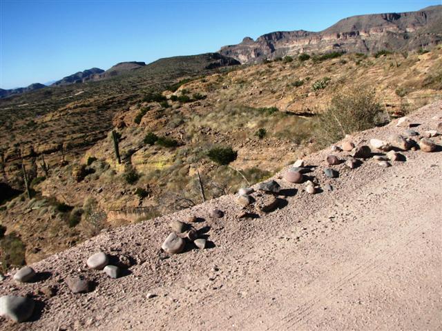
This is how close you were to the edge at times!
Notice the rock barricade hahahahaha!

We backtracked along the route that we had taken and ended up at a museum where this stagecoach was located. Pretty tight quarters for four people and I can only imagine the smooth ride it provided!

Well I guess we'll have to return to complete it another day. This was a nice way to get away from the city for a day. No serious vertigo although we both had popped a couple of pills along the way.
Today we went to check out the Apache trail. I thought that I had a first over my big brother, but alas, after talking to him he had already done the complete Apache Trail with Mardi! Damn!!
We drove to Apache Junction where we picked up #88 Hwy which was our starting point. The Apache Trail was built in the early 1900's to provide an access road for the building of the Roosevelt Dam. Some of the early photographs are mind boggling of what they had to go through. The trail also provided a means for Stage Coaches and Mule Trains to supply the town of Globe.
The first thing we came across was the Ghost Town and mine of Goldfield. Gold was discovered around Superstitious Mountain and this area once had a population of 4000.

Most of the buildings were on the original foundations and were very rustic and original looking.


Superstition Mountain sits in the background.

As we were leaving the Ghost Town, this old dude came riding in.

This is a Saguaro National Forest and this is a typical scene along the way. Saguaro cactus take up to 75 years to grow arms and can grow up to 50 feet and live up to 150 years! They can hold up to a ton of water.


We started working our way along the scenic Apache Trail and came upon Canyon Lake. If you look in the lower left corner of the picture you can see a bass boat working the shoreline.

There were a few hundred boats moored at the marina on Canyon Lake. A very popular place.
We moved along until we came to the town of Tortilla Flat (population 6).
This area was set up as a base camp to supply the Rockefeller Dam project. They still don't have phone service of any type here.

This is the original schoolhouse that is now a museum.

The stores were lined with one dollar bills!! The operator figured there was about $10,000 in bills on the walls and ceilings of the buildings!


We each had a prickly pear ice cream cone before we left (very tasty).
We continued on a few more miles before the road turned to gravel. There were some awesome views. Again the pictures don't do it justice.

Lots of switchbacks and speed was 15 mph in most places. We finally got to Fish Creek Hill a drop with a 10% decline and lots of switchbacks and had to turn around because the next 4 mile section had closed the day before and wouldn't reopen until late January. 8O(

You can see the Fish Creek Hill in this shot, declining from right to left. Notice the retaining wall on the right side of the picture that was built in the 1900's. You can also see the trail switching back and forth in the distance.

It was obvious why the road was closed when you looked at some of the roadway that we had proceeded on.

This is how close you were to the edge at times!
Notice the rock barricade hahahahaha!
We backtracked along the route that we had taken and ended up at a museum where this stagecoach was located. Pretty tight quarters for four people and I can only imagine the smooth ride it provided!

Well I guess we'll have to return to complete it another day. This was a nice way to get away from the city for a day. No serious vertigo although we both had popped a couple of pills along the way.
Subscribe to:
Posts (Atom)